

| Attribute Name | Label | Description |
|---|---|---|
| fid | ||
| id | ||
| id_CCarett | ||
| CCaretta |
Vector Data
Dec. 3, 2019, 11:48 a.m.
Abstract
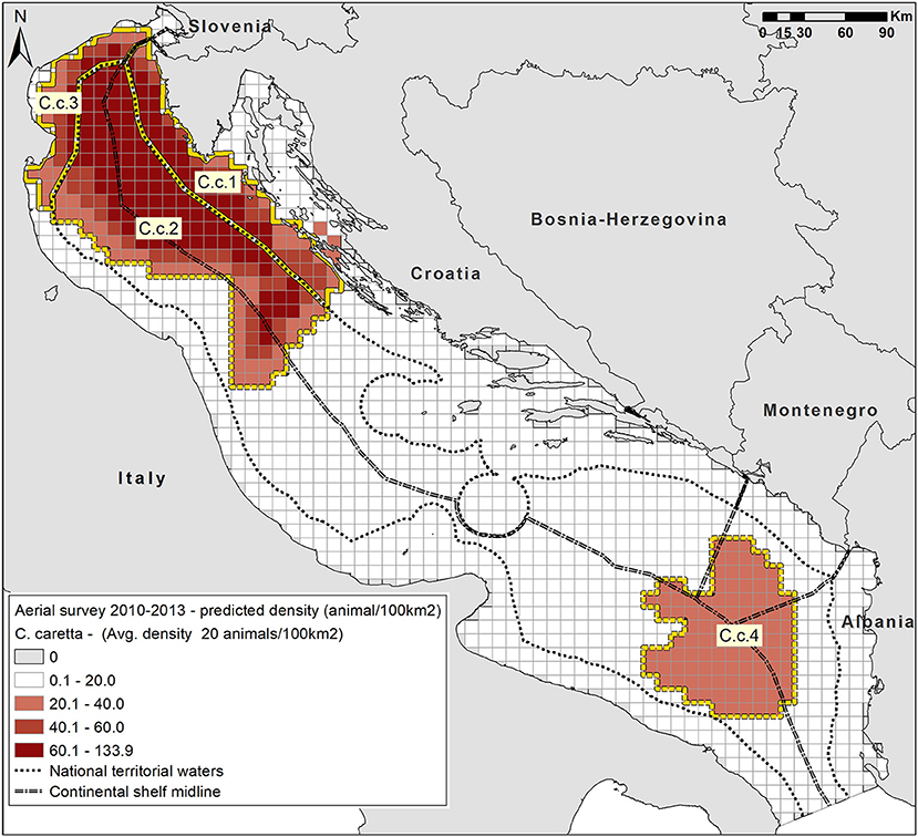
Density Surface predicted distribution of sea turtles (mostly loggerhead turtles Caretta caretta) in the Adriatic Sea based on 2010 and 2013 aerial surveys data (darker red scale indicates higher relative density, expressed in animals/100km2:
60.1 - 133.9 dark red
40.1 - 60 red
20.1 - 40 light red
0.1 - 20 white
0 gray ).
Geospatial data from Fig 2 ( https://www.frontiersin.org/files/Articles/409244/fmars-05-00356-HTML/image_m/fmars-05-00356-g002.jpg ) of Fortuna CM, Cañadas A, Holcer D, Brecciaroli B, Donovan GP, Lazar B, Mo G, Tunesi L and Mackelworth PC (2018) The Coherence of the European Union Marine Natura 2000 Network for Wide-Ranging Charismatic Species: A Mediterranean Case Study. Front. Mar. Sci. 5:356. doi: 10.3389/fmars.2018.0035
https://www.frontiersin.org/articles/10.3389/fmars.2018.00356/full
Layer WMS GetCapabilities document
- Language
- English
- Temporal Extent
- Jan. 1, 2010, midnight - Jan. 1, 2013, midnight
- Supplemental Information
Copyright © 2018 Fortuna, Cañadas, Holcer, Brecciaroli, Donovan, Lazar, Mo, Tunesi and Mackelworth. This is an open-access article distributed under the term...
- Spatial Representation Type
- vector line
Log in to add/delete Favorites.
Comments (0 total)
Log in to add a comment