- Title
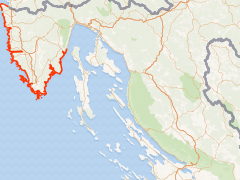
- Natural coastline-EO8-CI16-Istria County
- Abstract
Ecological objective EO8-Common Indicator 16-Lenght of coastline subject to physical disturbance due to the influence of manmade structures
- License
- Public Domain (PD)
-
+ Works in the public domain may be used freely without the permission of the former copyright owner.
+ For more info see http://www.copyright.gov/help/faq/faq-definitions.html. - Publication Date
- Feb. 19, 2020, 11:30 a.m.
- Type
- Vector Data
- Category
- Pressures impacts
- Pressures impacts
- Sub Category
- Other impacts
- Other impacts
- Regions
- Croatia
- Approved
- Yes
- Published
- Yes
- Featured
- No
- Name
- ZPUIZ ISTRIA (ZPUIZ_ISTRIA)
- latinka.janjanin@zpuiz.hr
- Position
- None
- Organization
- ZPUIZ_ISTRIA
- Location
- PULA HRV
- Voice
- None
- Fax
- None
- Identification Image
-
- Spatial Extent
- ---
- Projection System
- EPSG:3765
- Extension x0
- 264693.137371953000000
- Extension x1
- 321387.456258546000000
- Extension y0
- 4960823.400000000000000
- Extension y1
- 5044948.200000000000000
- Maintenance Frequency
- There Are No Plans To Update The Data
- Restrictions
- formal permission to do something
- Purpose
Report for PAP/RAC (October 2019.)
- Language
- English
- Supplemental Information
Report for PAP/RAC (October 2019.)
- Spatial Representation Type
- textual or tabular data is used to represent geographic data
- Name
- ZPUIZ ISTRIA (ZPUIZ_ISTRIA)
- latinka.janjanin@zpuiz.hr
- Position
- None
- Organization
- ZPUIZ_ISTRIA
- Location
- PULA HRV
- Voice
- None
- Fax
- None
- Link Online
- /layers_ext/geonode:Natural_coastline
- Metadata Page
- /layers_ext/geonode:Natural_coastline/metadata_detail
- OGC WMS: geonode Service
- Geoservice OGC:WMS
- OGC WFS: geonode Service
- Geoservice OGC:WFS
- Name
- ZPUIZ ISTRIA (ZPUIZ_ISTRIA)
- latinka.janjanin@zpuiz.hr
- Position
- None
- Organization
- ZPUIZ_ISTRIA
- Location
- PULA HRV
- Voice
- None
- Fax
- None
- Domain areas
- Istria marine area, Istria terrestrial area
- Data accessibility
- accessible
- Validation level
- official